DATA TERRA PARTNER OF THE OCEANIA GEOSPATIAL SYMPOSIUM 2022
The Oceania Geospatial Symposium (OGS) is a unique event serving the Pacific community that will be held from November 28 to December 4, 2022. The symposium aims to promote the use of space observation data applied to territory knowledge, water resources, wetlands monitoring and maritime activities in the Pacific area. DATA TERRA supports the organization of the OGS and will be present at the 2022 edition with its AERIS (atmosphere), FORM@TER (solid earth), ODATIS (oceans) and THEIA (continental surfaces) hubs and DINAMIS spatial imagery.
OGS 2022 is a symposium co-hosted by New Caledonia, French Polynesia and Wallis-and-Futuna, in partnership with ART Geodev, a network of knowledge centers dedicated to the spatial observation of territories and the environment. It brings together the French Research & Development Institute (IRD), the University of New Caledonia and a private company specializing in iEarth observation data imagery.
In a context of a global, climatic and social changes as systemic crisis, the United Nations has initiated the implementation of the Sustainable Development Goals (SDGs) which aim to promote prosperity while protecting the planet. At the regional and local levels, it is therefore necessary to set up policies for sustainable development and territories and/or resources monitoring. Pacific island states have to face growing needs with limited resources to meet them in order to fight climate change. Among the main key areas addressed, the OGS will focus on 3 central themes – territory knowledge, water resources and wetlands management – thanks to Earth observation data.
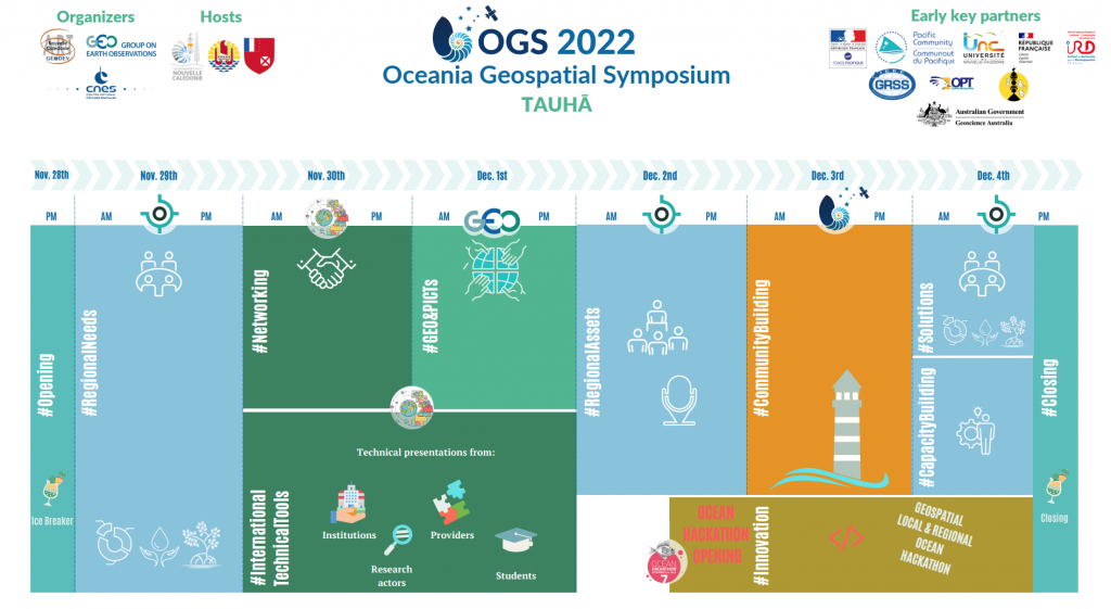
The symposium is organized by ART GeoDEV New Caledonia , GEO , SPC and CNES to promote the importance of using more Earth Observation data to observe, understand and analyze the environment, by pooling needs and resources and by strengthening regional collaboration in the field of space. The OGS 2022 aims to bring together actors around space in the heart of Oceania in order to help the local geospatial communities to know each other better, share practices, projects and priorities.
To know more :