2022 – EXTREME HEAT WAVES AND THEIR IMPACT IN EUROPE

In the last 3 months, France has reached temperature records in some cities never before recorded. Like other countries in Europe (Spain, Italy, etc.), heat waves have occurred, forests are still burning, parts of the continent are in the grip of long droughts, and the glaciers are breaking away.
Scientists are working to understand heat waves in Europe, their frequency and their intensity in order to enable societies to better protect themselves and try to reverse the trend. The persistent extreme heat also leads to a better understanding of the notion of climate within civil society. Climate is the weather in a given area over a long period of time, usually at least 30 years. This makes it possible to better detect and understand temperature anomalies in terrestrial and marine environments.
Based on four data centers and services corresponding to each of the major compartments of the Earth system, DATA TERRA makes it possible to access, combine and process data in order to respond to current challenges around extreme heat waves and the rise temperatures.
AERIS (atmosphere) – The study of forest fires in France
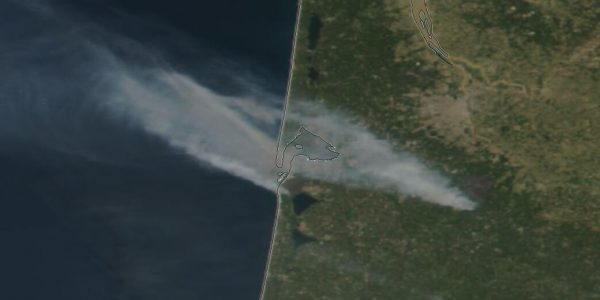
Temperature anomalies were observed using the IASI instrument (Atmospheric Infrared Sounding Interferometer). The violent forest fires that occurred in the south-west of France are visible thanks to the images of the Sentinel-3 and VIRRS satellites as well as those of the geostationary satellites recovered by the ICARE data center of AERIS, the atmosphere pole of DATA TERRA.
The heat wave in France was also observed thanks to the various campaigns of the PANAME 2022 research initiative , in which AERIS intervenes, studying air quality and urban climate in Paris. She was able to deliver the first results of the campaign placed under the sign of the heat wave last June. Finally, the ACROSS measurement campaign was able to provide airborne measurements and the pollution particles found in order to identify the sources and transformations of these chemical compounds.
FORM@TER (solid earth), THEIA (continental surfaces) and DINAMIS (HD satellite images) – The collapse of the Marmolada glacier in Italy and Kyrgyzstan
During the collapse of the Marmolada glacier in Italy the CIEST2 service was activated on July 6th. Thanks to the acquisition of Pleiades stereoscopic satellite images, scientists were able to determine the volume of ice detached. On July 10, 2022, a week after the collapse of the Marmolada glacier in Italy, a glacier in Kyrgyzstan also collapsed.
First, a digital elevation model (DEM) was generated from Pléiades stereo images using the DSM-OPT online tool provided by FORM@TER the solid earth pole of DATA TERRA, with THEIA, the continental surfaces hub and the DINAMIS system (HD space imagery). The elevation change was estimated by averaging the elevation changes around the detached area where ice was still present and the remaining elevation change due to collapse. The difference in elevation also includes the thinning of the glacier that occurred before the collapse.
Pléiades images can be acquired in stereoscopic and tri-stereoscopic mode. The DSM-OPT service allows the calculation of Digital Surface Models from Pléiades stereo/tri-stereo images, by uploading images from a computer or directly from the catalog of the DINAMIS
Effondrement glacier au Kirghizistan🇰🇬 la CIEST2 activé le 11/07 : le Pléiades 1A @CNES a acquis des images stéréo et le service DSM-OPT via @ForMaTerre a permis de calculer un DEM. Le volume de glace détaché a été estimé par @sgascoin @EtienneBerthie2🔗https://t.co/19QFxGgZaZ pic.twitter.com/omct5DTcJc
— ForM@Ter (@ForMaTerre) July 29, 2022
#Kirghizistan : un #glacier se détache et s’effondre sur 10 touristes qui filment la scène.
Par miracle, les 10 randonneurs sont sains et saufs. Selon les autorités, le glacier s’est effondré en raison de la fonte et du réchauffement climatique pic.twitter.com/ROLSix5UvD
— FRANCE 24 Français (@France24_fr) July 11, 2022
THEIA (land surfaces continentales) – The drought in France made visible by satellites
High definition satellite images cover France and the world and are obtained, for the most part, with the Sentinel, Spot and Pléiades satellites. They are systematically processed by satellite data researchers in order to contextualize them and allow them to be used as efficiently as possible by non-specialists.
The CESBIO in collaboration with the CNES and the THEIA hub of DATA TERRA, produces series of monthly Sentinel image mosaics to see the evolution of the drought on the hexagon between 2017 and 2022. Several other products are under development and to be discovered within the THEIA hub
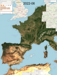
Monthly summaries from Theia for the months of June from 2018 to 2022. See the full animation on the CESBIO website
ODATIS – Marine heat wave in the Mediterranean area
The earliest heat wave ever recorded in France was in mid-June 2022 with extreme temperatures. These heat waves can also be observed in the oceans and estuaries, with significant and sudden increases in temperature impacting marine ecosystems.
Data from satellite observations and in situ measurements managed by the CERSAT and OASU data centers are made available in the ODATIS catalog and clearly highlight this episode.
Ocean surface temperature anomaly data (SST – Sea Surface Temperature) between June 16 and 20, 2022. ODATIS – Piollé J.-F., Autret, E. (2018),
To know more :